What is the size of Wyoming?
 Geography
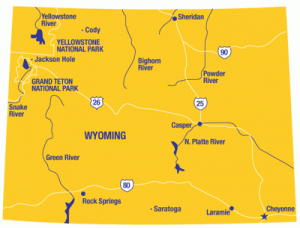
Known by the nicknames ‘Big Wyoming’, ‘Cowboy State’, and ‘Equality State’, the State of Wyoming is located in the Western part of the United States of America. It is largely dominated by rangelands and mountain ranges of the Rocky Mountains on the west. The eastern part of the state claims part of the High Plains – a prairie region that has a high elevation. Its boundary on the north is Montana, on the east are Nebraska and South Dakota, on the south are Utah and Colorado, and on the west are Idaho, Montana, and Utah. Straight lines are bounding the State of Wyoming making its shape like a rectangle.
Size
The State of Wyoming ranked as the ninth largest state in the United States of America in size. The total area of the state is 97,809 square miles or 253,325 square kilometers. The land area is 96,989 square miles or 251,201 square kilometers. The inland water area is 820 square miles or 2,124 square kilometers. Since the state is shaped like a rectangle, the length of its north to south border is 276 miles or 444 kilometers. The length of its east to west border at the south end is 365 miles or 587 kilometers and at the north end is 342 miles or 550 kilometers.
Population
The State of Wyoming may be one of the largest states according to size but the state has a small number of population. As of 2008, the estimated total number of population of the state is only 532,668 and ranked as the 50th populous state in the United States of America. Cheyenne is the most populous city of the State of Wyoming and it is also its capital city.
Physical Characteristics
The State of Wyoming is the meeting place of the Rocky Mountains and the Great Plains. The state is actually an immense plateau that is being split by a few significant mountain ranges. On the northwest portion are the mountain ranges of Absaroka, Wyoming, the Owl Creek, Gros Ventre, Teton, and Wind River. The Big Horns are in the north central while the Black Hills are in the northeast. And the mountain ranges on the southern portion of the state are Sierra Madre, Medicine Bow, and Laramie.
The Continental Divide runs through the State of Wyoming starting from the northwest and ending to the border on the south central. The rivers found on the east side of the Continental Divide are flowing into the Missouri River Basin which ends up to the Atlantic Ocean. These rivers are the Wind, Platte, Yellowstone, and Big Horn. The Snake River located on the northwest portion of the state is flowing to the Columbia River which ends up to the Pacific Ocean. While the Green River of the state drains to the Colorado River Basin which also ends up to the Pacific Ocean.

